")

WATER SUPPLY & INFRASTRUCTURE

INTRODUCTION
Climate change related shifts in precipitation, snowpack, and streamflow can alter the future supply and availability of water resources, as well as increase the need for improved water infrastructure to avoid stormwater pollution. Actions and implementation resources in this topic area are focused on water conservation and collection, stormwater management, and monitoring to create a more sustainable and resilient water supply for the North Olympic Peninsula and other rural areas facing similar challenges.
Top Actions: Water Supply & Infrastructure
Table of Top Actions
The table below incorporates key actions informed by best practices and other climate action and adaptation plans (see
Appendix). Each jurisdiction is different in its needs and capacity; therefore, the following table reflects a combination of hyper-local and regionwide adaptation and mitigation actions.
Action
Typical agencies or departments to implement
Adaptation or Mitigation
Climate change benefit
Invest in rain harvesting technology to collect non-potable water and infrastructure to infiltrate stormwater runoff into the ground
Parks, Facilities, Operations, Public Works
Adaptation
Improves water quality and creates more resilient waterways.
Create a rainwater harvesting and Low Impact Development program and incentives for residents
Parks, Public Works
Adaptation
Provides alternatives if water supply is low or at risk. Low impact development can act as a natural filtration mechanism and serve as a local flood buffer.
Promote household water conservation through rebates for water-efficient appliances, and provide education and outreach
Public Works
Adaptation
Improves water conservation.
Adopt regulations on Low Impact Development in new construction
Parks, Facilities, Operations, Public Works
Adaptation
Creates more resilient infrastructure and mitigates potential risks (e.g., flooding).
Adopt regulations requiring water-efficient appliances in government buildings
Facilities, Operations
Mitigation
Reduces water consumption and wastewater, which decreases emissions related to wastewater facilities.
Understand future projections for water availability in agricultural areas and educate farmers about water conservation and irrigation efficiency
Public Works, University consortiums
Adaptation
Supports local decision-makers in implementing water conservation strategies.
Identify water monitoring needs and enhance water supply monitoring
Public Works, Parks, and Water Utilities
Adaptation
Prepares cities and/or utilities to respond to potential future water supply issues.
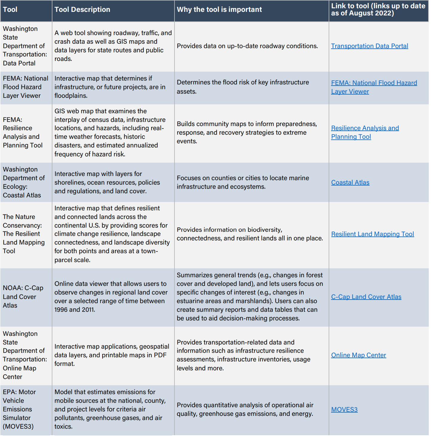
Tools: Water Supply & Infrastructure
Decision-making Tools
The table below provides a list of interactive, online tools jurisdictions can use to assess climate change impacts on their community and make decisions on climate change needs and strategies related to Water Supply & Availability.
Tool
Tool Description
Why the tool is important
Link to tool (links up to date as of August 2022)
USGS: WaterWatch
Realtime displays of maps, graphs, and tables describing real-time, recent, and past streamflow conditions for the U.S. updated on an hourly basis; highlights locations where flooding and droughts are occurring.
Shows where extreme hydrologic events (flooding, droughts) are occurring in real time and how current streamflow levels compare to historic streamflows.
WestWide Drought Tracker
Local, fine-scale drought monitoring with data sets, drought indices, and maps that are updated monthly.
Shows drought conditions and water-level data at a localized scale.
National Stormwater Calculator
Estimations for the annual amount of rainwater and frequency of runoff from a specific site using green infrastructure as low impact development controls.
Designed for use by anyone, including site developers, landscape architects, urban planners, and homeowners interested in reducing runoff from a property.
NOAA: Coastal County Snapshots
County level visualization tools including charts and maps of various “snapshots” including flood and sea level rise exposure.
Breaks down complex, county-level information related to coastal resilience to ensure future safety, a healthy environment, and a vibrant economy.
Advanced hydrologic predication service river forecasts
Interactive map that provides river forecasts, long-range river flood risks, and precipitation data at the national, state, and regional levels.
Shows trends in precipitation and flooding.
Snow Today: National Snow and Ice Data Center
Snapshots and interpretations of snow conditions in near-real time across the Western United States, told with a unique combination of satellite data and surface observations.
Identifies where snow is present, where it has recently snowed, how much water is in the snow, and how snow compares to historical trends.
Aqueduct Water Risk Atlas
Open-source, peer reviewed data and map of water risks such as floods, droughts and stress on a global to city specific scale.
Shows current and future water risk indicators (water stress, seasonal variability, water supply and demand) globally and on a local scale. The interactive map allows user to pick time frames and scenarios (optimistic, business-as-usual, and pessimistic) when viewing future prediction.
USDA: Water Supply Forecasts
A series of interactive maps, graphs, charts, and reports about water supply forecasts.
Provides monitoring information related to snowpack, streamflow, and drought conditions that can help managers plan for forecasted water availability.
UW Climate Impacts Group: Projected Changes in Extreme Precipitation
A web tool to visualize projected changes in heavy rainfall events across the Pacific Northwest as a function of decade, duration, and return interval (frequency).
Allows for customization based on geographic location, as well as options to download graphics and data.
Sample Codes, Regulations, and Plans: Water Supply & Infrastructure
Codes and Regulations
- Jefferson County Development Standards: Development codes related to water supplies, sewage disposal, and stormwater management.
- Jefferson County Rainwater Collection Policy Statement: Policy regarding use of rainwater collection systems for proof of meeting water adequacy requirements for a building permit.
- Clallam County Stormwater Management Code: Stormwater management code with minimum requirements for stormwater management and guidance on addressing illicit non stormwater discharges and illegal connections to public stormwater drainage systems.
- City of Bellingham Composting Toilets Policy: Code allowing composting toilets in any habitable building unless prohibited by regulations not enforced by the City of Bellingham.
- Groundwater Code, RCW 90.44.050: Requirements for water users to obtain authorization in the form of a water right permit or certificate from the Department of Ecology before withdrawing groundwater.
- Greywater Reuse for Subsurface Irrigation: Washington State legislation that provides building owners with simple, cost-effective options for reusing greywater for subsurface irrigation and associated requirements.
- Washington State EPA Water Quality Standards Regulations: Washington State water quality standards in effect for the Clean Water Act.
- WAC 173-308-193: Permitting management and exemptions for septage from composting toilets in Washington State.
- King County Board of Health Onsite Sewage Code 13.52: King County Codes for alternative on-site sewage methods, including holding tanks, composting and incineration toilets, etc.
Plans
- Port Angeles Stormwater Management Plan: Strategic guide to managing stormwater and surface water in Port Angeles.
- Sequim Stormwater Management Plan: Strategic guide to managing stormwater and surface water in Sequim.
- Washington State Department of Ecology Stormwater manuals: Stormwater manuals that provide permit implementation and management guidance, including a Stormwater Management Manual for Western Washington.
- Washington State Department of Ecology Water Quality Standards: Water quality standards for groundwater and surface water in Washington.
- Florida Rural Water Association New Water System Start-Up Checklist: New water system start-up checklist that covers technical, managerial, and financial capacity.
Resources: Water Supply & Infrastructure
The table below offers resources to implement the Water Supply & Infrastructure strategies and actions other jurisdictions have adopted and includes potential funding opportunities.
Resource
Description
Water Quality & Availability
Manual for stormwater managers and site designers that provides guidance for specific practices (i.e., flow reduction and water quality treatment credits that are applicable to the Puget Sound region) and to aid managers and designers to make informed decisions when adapting low impact development applications in their jurisdictions.
Information about water supplies and water quality issues in rural communities.
Technical assistance and funding for rural water projects.
Resources and information on water quality monitoring, pollution identification & correction (PIC), and spills and water quality concerns.
Sewer & Septic Systems
List of community drain fields, sewer services, and information on septic permits or inspections.
Educational, advisory, and permitting services for septic system owners and certifications for septic system installers.
Sample code language and information related to composting toilets.
Stormwater
Rebates for new development or redevelopment projects that result in less than 5,000 square feet of new or replaced hard surfaces and implement two or more of the following: permeable pavement, compost-amended soils in all distributed areas not covered by new improvements, rain gardens.
Information about stormwater monitoring permits and guidance.
Guide to Washington State stormwater management.
Recommended standards and guidance for performance, application, design, and operations and maintenance for water-conserving wastewater treatment systems, including composting, incinerating, vault, and pit toilets, as well as greywater systems.
Funding Opportunities
Provides information and resources for water quality-related funding opportunities.
Map that displays information about funded water quality projects and other Ecology-funded projects throughout the state.
EPA and non-EPA funding sources for small and rural community wastewater systems.
Supports planning and designing water infrastructure planning.
Information on the “what, where, and how” to apply for federal infrastructure dollars.
Federal technical and financial assistance programs that include funding opportunities for rural areas.