")

TRANSPORTATION & LAND USE

INTRODUCTION
Transportation is the largest source of greenhouse gas emissions for the North Olympic Peninsula and many rural areas. As such, governments across the North Olympic Peninsula are looking to incorporate strategies to reduce vehicle miles traveled via public transportation investments, development changes, and increased electric vehicle (EV) usage. Furthermore, climate change will impact many of the region’s critical transportation routes, particularly those located in coastal, flooding, and landslide prone areas. Making climate-smart land use decisions such as minimizing development in areas most vulnerable to climate change and designing walkable, dense communities can lower the region’s carbon footprint and improve community resilience.
Top Actions: Transportation & Land Use
Table of Top Actions
The table below incorporates key actions informed by best practices and other climate action and adaptation plans (see Appendix). Each jurisdiction is different in its needs and capacity; therefore, the following table reflects a combination of hyper-local and regionwide adaptation and mitigation actions.

Tools: Transportation & Land Use
Decision-making Tools
The table below provides a list of interactive, online tools jurisdictions can use to assess climate change impacts on their community and make decisions on climate change needs and strategies related to Transportation & Land Use.
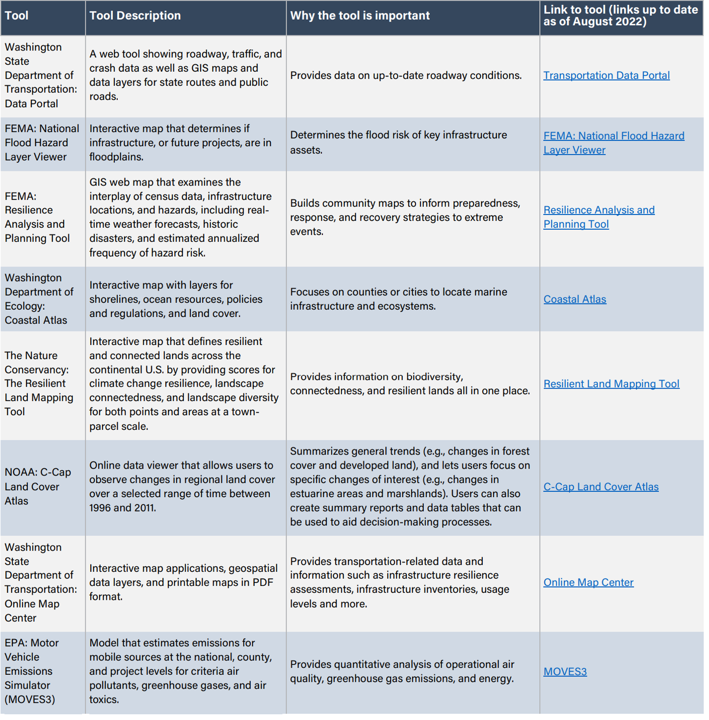
Tool
Tool Description
Why the tool is important
Link to tool (links up to date as of August 2022)
Washington State Department of Transportation: Data Portal
A web tool showing roadway, traffic, and crash data as well as GIS maps and data layers for state routes and public roads.
Provides data on up-to-date roadway conditions.
FEMA: National Flood Hazard Layer Viewer
Interactive map that determines if infrastructure, or future projects, are in floodplains.
Determines the flood risk of key infrastructure assets.
FEMA: Resilience Analysis and Planning Tool
GIS web map that examines the interplay of census data, infrastructure locations, and hazards, including real-time weather forecasts, historic disasters, and estimated annualized frequency of hazard risk.
Builds community maps to inform preparedness, response, and recovery strategies to extreme events.
Washington Department of Ecology: Coastal Atlas
Interactive map with layers for shorelines, ocean resources, policies and regulations, and land cover.
Focuses on counties or cities to locate marine infrastructure and ecosystems.
The Nature Conservancy: The Resilient Land Mapping Tool
Interactive map that defines resilient and connected lands across the continental U.S. by providing scores for climate change resilience, landscape connectedness, and landscape diversity for both points and areas at a town-parcel scale.
Provides information on biodiversity, connectedness, and resilient lands all in one place.
NOAA: C-Cap Land Cover Atlas
Online data viewer that allows users to observe changes in regional land cover over a selected range of time between 1996 and 2011.
Summarizes general trends (e.g., changes in forest cover and developed land), and lets users focus on specific changes of interest (e.g., changes in estuarine areas and marshlands). Users can also create summary reports and data tables that can be used to aid decision-making processes.
Washington State Department of Transportation: Online Map Center
Interactive map applications, geospatial data layers, and printable maps in PDF format.
Provides transportation-related data and information such as infrastructure resilience assessments, infrastructure inventories, usage levels and more.
EPA: Motor Vehicle Emissions Simulator (MOVES3)
Model that estimates emissions for mobile sources at the national, county, and project levels for criteria air pollutants, greenhouse gases, and air toxics.
Provides quantitative analysis of operational air quality, greenhouse gas emissions, and energy.
Sample Codes, Regulations, and Plans: Transportation & Land Use
Codes and Regulations
- Electric Vehicle Infrastructure: A Guide for Local Governments in Washington State: WA Department of Commerce and Puget Sound Regional Council’s 2010 report that details model ordinances, model development regulations, and guidance related to EV infrastructure and batteries per RCW 47.80.090 and 43.31.970.
- Walla Walla: EV Infrastructure Ordinance: An ordinance to provide guidance around EV charging station placement and installation for the travelling public, residents in residential dwellings, and customers and employees in commercial and industrial spaces.
- Seattle Commuter Benefit Ordinance: An ordinance requiring businesses with 20 or more employees to offer employees the opportunity to make a monthly pre-tax payroll deduction for transit or vanpool expenses in order to encourage commuters to use transit options other than single occupancy vehicles, thus reducing traffic congestion and carbon emissions.
- Essential Smart Growth Fixes for Rural Planning, Zoning, and Development Codes: Suite of policy options that can help rural communities ensure that development is fiscally sound, environmentally responsible, and socially equitable while preserving rural character. Topics include fiscal impact analysis, commercial development, wastewater infrastructure, rural roads, and efficient development patterns.
Plans
- WSDOT Electric Vehicle Action Plan (2015-2020): The Washington State Department of Transportation recommendations for 13 action items to increase the adoption of plug-in electric vehicles in Washington.
- Peninsula Regional Transportation Planning Organization (PRTPO): Coordinated Public Transit-Human Services Transportation Plan: A planning tool to help the PRTPO identify public transportation needs and to provide recommendations to benefit those individuals who depend on public transportation services.
- WSDOT Guidance for Considering Climate Change in Planning: A guide to help plan for sustainable multimodal transportation systems while considering climate change impacts.
Studies & Reports
- Creating a Resilient Transportation Network in Skagit County: Using Flood Studies to Inform Transportation Asset Management Report: A study conducted by WSDOT to develop options for improving the resiliency of transportation facilities and systems to climate change and/or extreme weather events.
- Peninsula RTPO: Peninsula Regional Non-Motorized Connectivity Study: A study that brings together existing information on regional non-motorized facility connectivity into a comprehensive map with consistent definitions and identification of non-motorized facility types, gaps, and options to close the gaps.
- WSDOT’S Climate Impacts Vulnerability Report: A statewide assessment of climate vulnerability of state-owned transportation assets.
- Using Smart Growth Strategies to Foster Economic Development: A policy toolkit developed by Kelso, Washington and the EPA addressing land use, transportation, health, and economic and workforce development policies that will help steer infill development and redevelopment to existing communities, creating a diversified economic base.
- Transportation Research Board’s Transit Cooperative Research Program Synthesis 94: Innovative Rural Transit Services highlights transit and rural intercity bus service responses to changing rural community transportation needs. The report includes an emphasis on the innovative and/or entrepreneurial spirit, the innovator, and the conditions required for innovation.
Resources: Transportation & Land Use
The table below offers resources to implement Transportation & Land Use strategies and actions other jurisdictions have adopted and includes potential funding opportunities.
Resource
Description
Mobility
A resource for rural and small urban transit agency managers for predicting and managing operational costs.
An initiative to address disparities in rural transportation infrastructure and priorities to meet transportation goals of safety, mobility, and economic competitiveness through user-friendly tools, information, DOT resources, and providing technical assistance.
Recreation
Reports and information about how an outdoor recreation economy can revitalize community, protect air and water quality, create jobs, and support economic growth.
Land Use Planning
Training materials, worksheets, and activities developed to help communities and ports develop collaboration skills and to enhance understanding of stakeholders’ priorities and challenges associated with port-related activities.
Planning, regulatory, and spending tools for adaptation for governments and policymakers to help manage the complexity of adaption for sea level rise (SLR). The purpose is to help state and local planners identify potential responses after they have assessed their jurisdictions’ risks and vulnerabilities to SLR.
Step-by-step guide for small and mid-sized cities—particularly those that have limited population growth, areas of disinvestment, and/or a struggling economy—to build a place-based economic development strategy.
Maps showing how the WUI has changed over the past three decades in the U.S. to support land use policies and decision-making.
Electric Vehicles
A working resource page subject to frequent changes. Users can learn about the Peninsula EV Infrastructure Exchange Group and contribute resources.
A one-stop resource to help rural communities scope, plan, and fund EV charging infrastructure. This toolkit is intended for a variety of rural stakeholders, including states, local communities, Tribes, transportation providers, nonprofits, businesses, and individuals.
Funding Opportunities
Supports local efforts to improve connectivity between counties and regional population centers as well as to reduce transportation delay. This program includes four eligible project types: vehicle and equipment purchases, capital construction, operations, and transportation demand management.
Supports rural and small urban areas. Grant recipients use these funds to purchase or enhance vehicles and facilities as well as support operations.
Supports local jurisdictions to reduce greenhouse gas emissions and keep the busiest commute routes flowing. Local jurisdictions work with employers, who develop and manage their own programs based on locally adopted goals.
Provides funds for public transportation improvements within and between rural communities, transportation services between cities, purchases of new buses and equipment, and transportation services for seniors and people with disabilities.
A state transportation funding package that provides $3 billion for public transportation over the next 16 years. Move Ahead Washington funding will add support to existing programs and lead to the development of new programs.
Supports essential community facilities in rural areas. An essential community facility is defined as a facility that provides an essential service to the local community for the orderly development of the community in a primarily rural area, and does not include private, commercial, or business undertakings.
Supports projects to improve and expand the surface transportation infrastructure in rural areas to increase connectivity, improve the safety and reliability of the movement of people and freight, and generate regional economic growth and improve quality of life.
